
This Christmas, with my planned trip Morocco and then Spain trips canned due to omicron-induced border closures, I pushed my 1992 black XT600e into the back of the van and headed to north Wales for four days and then the Yorkshire Dales for a week.


One of the great things about trail riding nowadays is that’s it’s so easy to get started; all you need is a motorbike, a smartphone with a handlebar mount and a good old fashioned dollop of ‘get up and go’. A myriad of different routes in countries around the world have been shared online through apps like Viewranger/OutdoorActive and WikiLoc, which have made byways that were once only known to local trail riding groups accessible to people anywhere in the world. The Trans Euro Trail has also been a great force for opening up the hobby too, providing an easy and valuable reference for even more experienced riders to dip in and out of.
This is pretty much how I learnt to ride off-road after coming back from riding London to Sydney five years ago. But whilst it was convenient for easily finding places to do to practice riding, I quickly grew bored of simply following others’ routes. I’d often find that I’d get to the end of a ride with an unsatisfactory feeling, like something was missing. This, of course, is why a lot of people caution against simply using a GPS or Google Maps to navigate on long-distance bike trips, whether they are on or off-road.


As my skills and confidence in riding off-road have improved, then so has my ability to engage with my surroundings. I’ve found that planning and taking my own routes on a map is a good way of tackling that lack of satisfaction that comes from just following others’. Taking the time to to do so means you’re automatically far more invested in the ground you are going to cover, as the contours and symbols you consider on a map beforehand then come to life in the real world as you ride through them. At the same time, more confidence and skills on the bike doesn’t mean you’re spending all your time staring straight ahead or wrestling with the ground conditions. You have a greater capability to engage.
There has been a further iteration of this that I have wanted to try for some time. Almost all of my riding has tended to be ‘thru routes’ that have some final destination in mind, but this Christmas, I decided to take a different approach; instead of a route where I stopped and stayed at different places each night, I decided to stay in one location, establish a base and do a series of trips around the local area to and from there.


The purpose of this idea was simple – to spend more time focussed in one particular area to explore it via trails by bike to its fullest extent, to get a better sense of all that is in that area in terms of both physical and human geography. And of course to enjoy riding those trails and to get some good photos too.
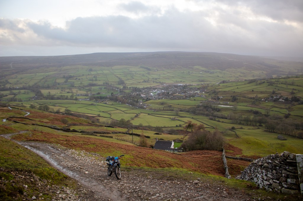
This worked a treat, particularly in the Yorkshire Dales, where I had a full week based out of a cottage in Low Row, in Swaledale, though the preamble of a couple of days’ riding in Wales also came up trumps too.
Using OS Maps on OutdoorActive, I plotted a series of loops each night for the following day, concentrating on one area at a time. Whilst I’ve ridden the trails in the Dales before, including the Trans Euro Trail section, if you asked me to place them on a map I couldn’t have done so. I couldn’t tell you where the Roman road out of Bainbridge was, where that route I did a few summers ago with a big chimney was, which ended in village with a castle. And I certainly didn’t know where Swaledale, Wharfedale, Ribbledale or Widdale were. Which is a shame, because I must have ridden in the Dales at least three or four times in the last five years.
This was the rationale behind the change of tack. And to my surprise, after seven days I’d done maybe only two-thirds of the byways and unclassified roads that are in the national park; I thought there’d only be a few days riding at most. I left knowing I could have quite happily done another few days’ good riding but also having felt like I’d properly explored the areas I’d been to.


So, what did I take away from all of this?
Tension between the journey and the destination. This way of doing things obviously eliminates the inherent tension that exists with any ‘thru-route’ between focussing on a final destination and ensuring your seeing/appreciating everything you can see in a given area; you’re not simply leaving behind one area and moving on, never to return, but knitting them all together over a number of days. You have more discretion about how much time you can spend in places as well, both in terms of not having that pressure of a final destination and in terms of knowing that you’re concentrating your efforts in a smaller area.
Greater involvement in the geography. Both through the route planning process and the actual of practice of riding the bike, you’re obviously much more involved in the geography on the ground because you’re going back and forth, exploring the same area. Plotting your own routes beforehand, rather than just winging it entirely, allows you to get a feel for that ahead of time but then when out riding you’ve got the freedom and the time to take in the landscape you come across and what it has to offer because you don’t feel like you’ve got be somewhere in the same way as with a ‘thru-route’. See point 1 above. That also extends to how different routes and loops link together in the grander scheme of things, giving you a deeper understanding of the area.
It allows you to establish a base. This is useful from both a practical and comfort perspective, particularly in winter. In the most basic, practical sense, I had my van with me with a load of tools and spares which was useful in Wales after damaging the bike on the infamous ‘Bastard Lane’ just north of Machynlleth. Having a roof over my head allowed me to plan better for the next day, both from a comfort perspective and from a growing familiarity of the local area perspective (see point 2). Having this base provides a consistent, central focus for where you plan your routes.

I came away with a far more satisfying experience than I have had on similar trips, despite the seemingly non-stop Pennine rain over the Christmas period, feeling like I’d taken an approach that struck a far better balance between having a sense of direction and getting the most out of your immediate surroundings. I felt like I’d properly explored the Dales in particular, getting more out of the trip than the others I’d done there.
The next question, as I think towards when cross-border international motorbike travel will become easier once again, is how does this translate when planning longer, multi-day or even multi-week trips? Will I simply continue this approach, perhaps moving on every few days with no final, grand destination in mind but just decide on an area to explore? Or do I strike a balance between this way of travelling and the way I’ve been used to, and set that destination with an ambition that’s more limited than it might have otherwise been, to give me more time to spend en route?


One thought on “Thru or around?”